Great Divide
Trail
A 1,130km point-to-point traverse where route continuity is never guaranteed.
Classification
Remote Expedition-Level Trek
Duration
55 days
Route distance
1130.0km
Vertical Gain
+44,000m
Max Altitude
2,590m
Official max 2,590m (2,800m+ via alternates)
Mission Brief
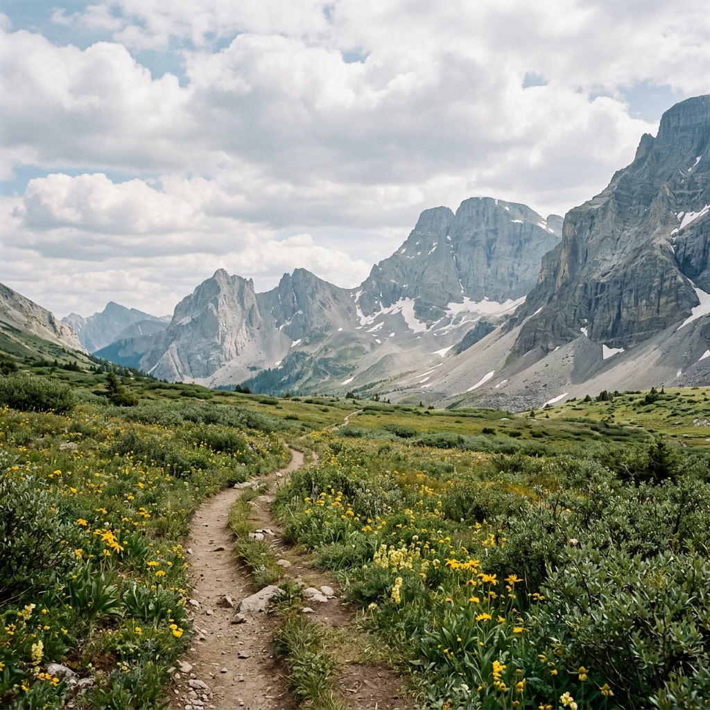
The wild heart of the Rockies. Stretching over 1,100km from Waterton Lakes National Park to Kakwa Provincial Park, the Great Divide Trail (GDT) is a loosely connected series of trails, old forestry roads, and off-trail cross-country segments. It follows the Continental Divide, crossing between Alberta and British Columbia dozens of times.
Unlike more established National Scenic Trails, the GDT is often a "choose your own adventure" experience where the path frequently vanishes into scree slopes or dense willow bushwhacks. Hikers must be prepared for extreme isolation, technical river crossings, and the relentless verticality of the Canadian Rockies.
Self-reliance, resupply discipline, bear awareness, and exit planning are core safety systems.
Mission Snapshot
Intensity Breakdown
Understanding what drives the overall route demand
Physical
88
Technical
75
Commitment
93
Primary driver: Extreme Remoteness & Self-Reliance
- Frequent off-trail navigation and route ambiguity
- Frequent grizzly bear presence in remote sections
- Extended resupply gaps (150–250 km)
- Limited exit points and prolonged isolation
Major expeditions for elite teams. Sustained isolation and technical mastery required.
Full Route Breakdown
Complete stage overview with transparent route metrics. Values are shown as recorded in the route dataset and source links.
Distance
1130.0 km
Ascent
44,000 m
Highest point
2,590 m
Start
Waterton Lakes National Park
Finish
Kakwa Lake / Walker Creek Road
Use the KM / MI toggle in the main menu to switch units.
Route Profile
Route Considerations
The GDT is not mountaineering by default, but it is still a lethal-serious wilderness commitment: remoteness, grizzly habitat, river decisions, rough tread, route ambiguity, and limited rescue options leave little margin when fatigue or weather compounds.
Extreme remote navigation failure risk
The trail frequently disappears into high alpine meadows or dense forests, and many markers are non-existent.
Impact
Route-specific
Likelihood
Context-dependent
Tip
Expert-level navigation skills are required; carry an InReach or Zoleo for satellite communication; use the FarOut (GDT) app as a primary digital resource but always have high-detail paper backups.
High grizzly density throughout the route
The GDT passes through some of the most densely populated grizzly habitat in western Canada. Encounters are possible throughout, particularly in berry patches and near water sources.
Impact
Route-specific
Likelihood
Context-dependent
Tip
Bear-resistant food storage is strongly recommended; check specific park regulations as requirements vary (hard-sided canisters, Ursacks, or food hangs may be acceptable depending on the section). Carry two cans of bear spray; travel in pairs where possible; be hyper-vigilant in berry patches and near water sources.
Dangerous glacial river crossings
Summer melt can turn crossings into serious mid-day hazards. They are intermittent along the corridor—not a defining daily gate on every mile the way braided glacial rivers structure whole days on some Arctic routes like the Akshayuk Pass. On the GDT, rivers are a tactical hurdle; on Baffin, they are a structural blockade.
Impact
Route-specific
Likelihood
Context-dependent
Tip
Plan to cross all major rivers before 9:00 AM; know how to unclip your pack waist belt before entering; search for wider, multi-braided sections of the river for easier crossing.
Why hike this route?
LANDSCAPE
Jagged limestone peaks, turquoise glacial lakes, and endless alpine meadows.
VARIETY
The total shift from the semi-arid South to the lush, wet, and wild North.
CULTURE & PLACE
A small, tight-knit community of 'divide-hikers' who share a deep love for the rawest form of wilderness.
STANDOUT
The Uncharted Wilderness and the Kakwa Finish. What sets the GDT apart is its raw, unpolished nature. Large sections are not official trails and are maintained entirely by volunteers. Finishing at Kakwa Lake—where there is no road access—marks the end of a journey into some of t…
Expert Verdict
“The GDT is widely regarded as one of the most demanding thru-hikes in North America. Unlike the well-maintained PCT or CDT, the GDT frequently has no visible trail; hikers must rely on topographic map reading and GPS waypoints. Bushwhacking speeds through dense alder and willow can drop to 1 km/h. Relative context: More remote and technically demanding than the Pacific Crest Trail, but with lower overall altitude. The grizzly density in Sections D-F is comparable to the Yukon interior. Practical thru-hike notes: Average daily distance is 25-30km on trail sections, but drops to 10-15km on bushwhack days. Most thru-hikers complete the route in 45–70 days; southbound (Kakwa → Waterton) is slightly more common as it saves the hardest navigation for when you are trail-fit. Resupply gaps: Coleman to Banff (~200km), The Crossing to Jasper (~200km), Jasper to Kakwa (~250km with zero resupply). Food carries of 10-14 days are standard for the northern sections. Snow travel on high passes is common until mid-July; microspikes or light crampons may be needed. Permit complexity: There is no single GDT permit. You need separate backcountry permits for Banff, Kootenay, Yoho, and Jasper National Parks, plus provincial park registrations for BC and Alberta sections. Key campsites (Berg Lake, Floe Lake) sell out in January. Total permit costs range $200-400 CAD depending on itinerary.”
Who This Is For
- EXPERT (ELITE THRU-HIKER) — For those who find the PCT too crowded or the AT too easy. You must be an expert navigator comfortable with 'route-finding' in trackless wilderness and deep grizzly territory.
- PHYSICAL — Very High. Carrying 10-14 days of food over multiple 2,500m passes while 'bushwhacking' through dense alder requires peak physical and mental conditioning.
- WATCH FOR — The Saskatchewan Crossing trap: Section E is a navigational and logistical crux; resupply requires advance shipping or a difficult hitch.
- WATCH FOR — Calculating the finish at Kakwa Lake: You must walk another 28-75 km to reach Walker Creek Forest Service Road for vehicle access.
Plan This Hike
Key things to arrange before starting this route—practical tips first, then buttons that open curated picks (gear, maps, stays) where we list them.
Expert Recommendation
Practical next step for this hike:
Not the most technical trail — but one of the most committing and remote routes you can hike without mountaineering skills.
- Self-supported wilderness navigation required
- Grizzly management is a daily factor
- Mental resilience for 45–70 days of isolation
- Expert-level route finding in Section G
Essential Gear
Recommended preparation for this route:
Multisport expedition kit for 1100km+ of rugged terrain.
- Bear-resistant food storage (mandatory)
- Satellite SOS device (InReach/Zoleo)
- High-silt water filtration system
Stay Connected
Explore accommodation options for this trail:
Critical map data for trail-less navigation.
- FarOut GDT Guide App (offline)
- Paper Map + Compass backup
- Solar or large capacity powerbank
Getting There
Travel and trail access for this route:
Waterton South to Kakwa North logistics.
- Fly to Calgary (YYC) for South start
- Shuttle to Waterton Lakes trailhead
- Arrange Kakwa retrieval in advance
Where to Stay
Explore accommodation options for this trail:
Permit-heavy wilderness camping strategy.
- Early Q1 permit window (Feb/March)
- Staggered Parks Canada release dates
- Respect random camping guidelines
Compare This Route
See how this route compares to similar hikes in overall demand and terrain profile.Compare routes by the shape of the effort, not only the headline score.
Piuquenes Pass
Closest overall match in demand profile
Following the historic path used by the Army of the Andes in 1817, this 6-d...
Intensity
Lower intensityMount Damavand Summit
Lower overall intensity, similar terrain type
Mount Damavand (5,610m) is the highest peak in Iran and a major Asian strat...
Intensity
Lower intensityInner Dolpo
Higher physical or technical demand
The hidden land of Bon. Inner Dolpo is a prehistoric landscape of high-alti...
Intensity
Higher intensityExplore Alternatives
Broaden the picture with easier, harder, and nearby options.
Looking for something easier?
Lower intensity — helpful if this route feels like a stretch right now.
Want more challenge?
Higher intensity — for when you are ready for a bigger physical or technical step.
More hikes in this region
Nearby and regionally relevant routes for the next step in your search.
Akshayuk Pass
nunavut · canada
Distance
97.0 km
Ascent
970 m
Chilkoot Trail
british-columbia-alaska-border · canada
Distance
53.0 km
Ascent
1,067 m
Long Range Traverse
gros-morne-national-park-newfoundland · canada
Distance
35.0 km
Ascent
700 m
Sunshine Coast Trail
british-columbia · canada
Distance
180.0 km
Ascent
6,000 m
The West Coast Trail
Vancouver Island (British Columbia) · canada
Distance
75.0 km
Ascent
1,813 m
The Rockwall Trail
british-columbia · canada
Distance
54.0 km
Ascent
2,600 m
Compare with any route
Pick any hike worldwide and open a full side-by-side comparison.
What You Need to Know
Essential answers about the demands, risks, and logistics of this route.
Q.How hard is this hike really?
Q.Do I need technical gear?
Q.Is water available on the route?
Q.What is the main risk?
Ready to hike Great Divide Trail?
A final decision point after reviewing the route, risks, logistics, and alternatives.
This route is a strong match if you're comfortable with the effort level implied by an Intensity Score around 90/100 (Remote Expedition-Level Trek), sustained hiking where this route requires it, and the terrain and exposure described in this guide.
Build your itinerary, stages, and logistics.
Looking for something easier, more challenging, or a different terrain profile?
Compare routes by intensity, terrain, and region.