Akshayuk
Pass
A high-risk 97km Arctic expedition beneath the world's most dramatic granite walls.
Classification
Arctic Expedition
Duration
12 days
Route distance
97.0km
Vertical Gain
+970m
Max Altitude
420m
Arctic watershed conditions with extreme exposure to polar weather cycles
Mission Brief
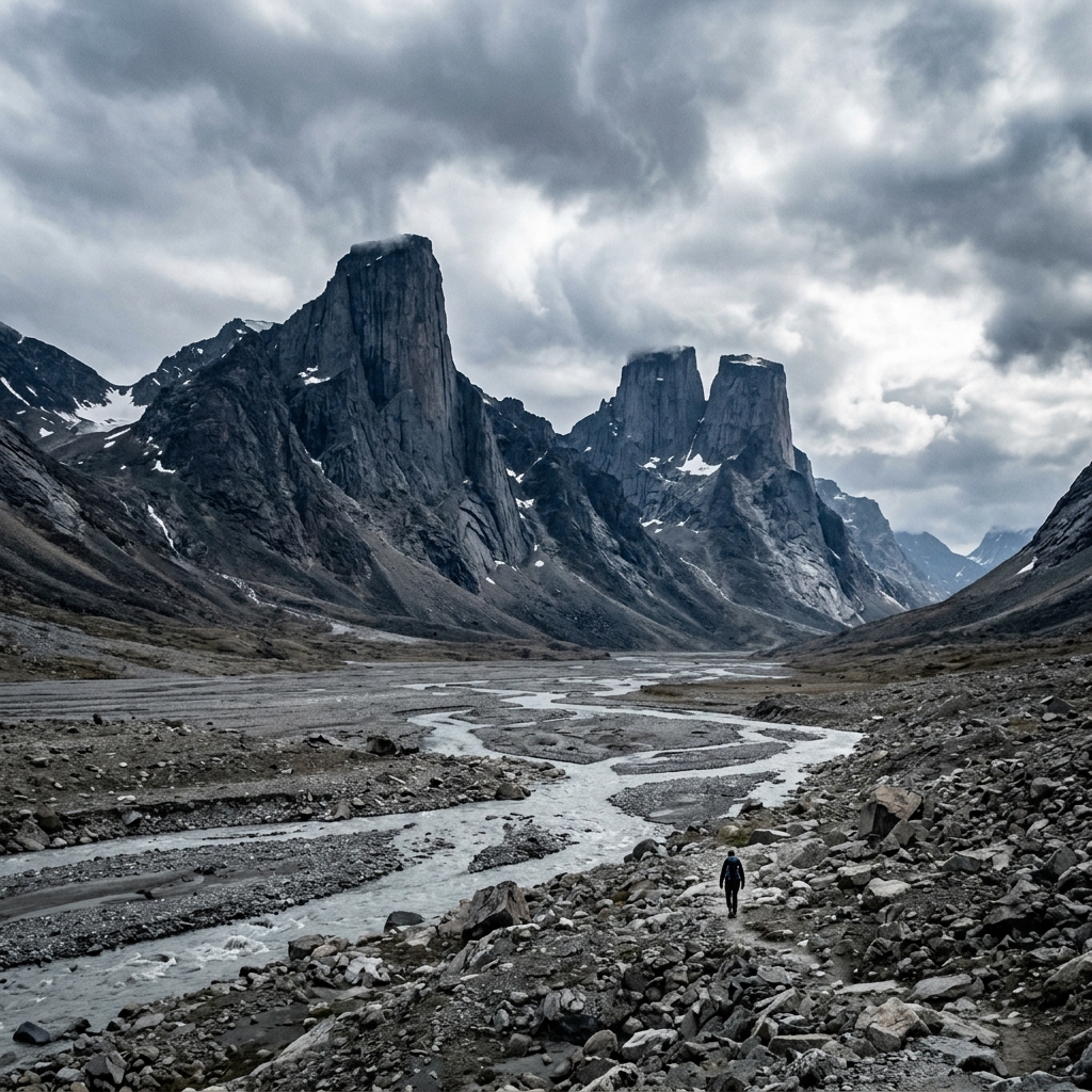
A high Arctic traverse through granite giants. The Akshayuk Pass in Auyuittuq National Park is an approximately 97km traverse across Baffin Island, at or just above the Arctic Circle. This is a land of sheer granite towers: Mount Asgard and Mount Thor (featuring one of the world's greatest uninterrupted vertical drops (1,250m), with a west face that averages 15° past vertical) rise above ancient glaciers. Navigation relies on Inuksuit (stone cairns) and topographical intuition; there are no marked trails, no bridges, and no cell service.
It is a raw, demanding journey through a landscape shaped by ice ages, where distances feel larger than they are and progress is often dictated by terrain and weather rather than the map. Once committed, you are fully self-reliant in a place where conditions can change quickly and retreat is rarely straightforward.
Constant glacial river crossings and polar bear risk require advanced expedition skills.
Mission Snapshot
Intensity Breakdown
Understanding what drives the overall route demand
Physical
75
Technical
68
Commitment
100
Primary driver: Total Isolation & Environmental Risk
- No exit once committed
- Glacial rivers as critical decision points
- Polar bear territory (active risk management)
- Volatile Arctic weather systems
Major expeditions for elite teams. Sustained isolation and technical mastery required.
Full Route Breakdown
Complete stage overview with transparent route metrics. Values are shown as recorded in the route dataset and source links.
Distance
97.0 km
Ascent
970 m
Highest point
420 m
Start
Weasel Valley Entry
Finish
Owl River Descent
Use the KM / MI toggle in the main menu to switch units.
Route Profile
⚠ Elevation profile significantly underrepresents the true difficulty. Terrain friction penalty: 1km on Baffin moraine ≈ 3km on groomed trail. Rivers are the primary fatigue driver.
Operational Reality
Daily distances and camp locations are highly variable and dictated by river conditions, weather, and terrain. Fixed stage planning is not realistic.
Route Considerations
Critical Isolation. Polar bear risks require 24/7 vigilance and firearm/deterrent proficiency where regulations allow; there is zero infrastructure to assist in an encounter. Volatile Arctic storms and dangerous glacial river surges can turn life-threatening within hours, stall progress for days, and make fixed itineraries impossible.
Unbridged river crossings
Glacial river surges are the primary hazard; water levels can reach waist-deep with invisible river bottoms due to 'glacial milk' (fine rock flour) silt.
Impact
Route-specific
Likelihood
Context-dependent
Tip
Cross before 9 AM; three-point method with pack straps unclipped; scout for widest braids.
Arctic volatility
Sudden hurricane-force Arctic storms can destroy standard tents. Polar bears are a critical safety factor; risk increases significantly at the North end (Owl River corridor / Delta).
Impact
Route-specific
Likelihood
Context-dependent
Tip
Mandatory park briefing registration; carry satellite messenger; use expedition-grade shelters.
Terrain & conditions
Conditions change quickly on the ground. Slow down on wet rock and pay more attention where paths narrow or exposure increases.
Impact
Moderate
Likelihood
Variable
Tip
Refer to stage notes and expert briefings; maintain focus on slick or exposed sections.
Why hike this route?
LANDSCAPE
The world's highest vertical rock face at Mount Thor and the architectural granite of Asgard.
VARIETY
A transition from silty river deltas to ancient glacial moraines and high tundra.
CULTURE & PLACE
A profound connection to the scale and silence of Nunavut's wild interior.
STANDOUT
Total environmental commitment. The scale of Mount Thor's 1,250m vertical face is matched only by the isolation of a traverse where extraction is weather-dependent and days from help.
Expert Verdict
“The Akshayuk Pass is the gold standard for Arctic traverses. The difficulty isn't in vertical gain, but in the total absence of infrastructure and high-consequence logic. Exercise extreme caution on wet lichen-covered moraine; it acts as black ice. River crossings are the tactical focus: cross early (before 9 AM), cross wide, and never hesitate to wait out a surge. Practicality: terrain friction is extreme—expect to average 1.5km/h even on 'flat' sections. Note: the finish at North Pangnirtung Fiord is a remote beach; boat pickups are weather-gated and bear risk is maximum here.”
Who This Is For
- EXPERT — Advanced wilderness travelers only. Proficient in river crossing techniques, wilderness first aid, and satellite navigation.
- PHYSICAL — Heavy. Navigating moraines and tundra with an expedition-weight pack (20kg+) is the primary physical challenge.
- WATCH FOR — Afternoon river crossings when glacial melt is at its peak.
- WATCH FOR — Underestimating the drag of soft sand in the Weasel River delta.
Plan This Hike
Key things to arrange before starting this route—practical tips first, then buttons that open curated picks (gear, maps, stays) where we list them.
Tactical Timing
Practical next step for this hike:
Strategize around glacial melt cycles.
- Cross rivers before 9 AM
- Monitor flow levels hourly
- Prioritize safety over schedule
Arctic Gear
Recommended preparation for this route:
Deploy expedition-grade equipment.
- 4-season wind-rated tent
- Dedicated river shoes
- Satellite backup mandatory
Security Gate
Practical next step for this hike:
Secure mandatory park clearance.
- Register at Pangnirtung
- Attend safety briefing
- Validate bear registration
Access Logistics
Travel and trail access for this route:
Coordinate charter transport.
- Book boat charters early
- Plan for weather delays
- Iqaluit flight connections
Basecamp Logic
Practical next step for this hike:
Apply Arctic camping protocols.
- LNT Arctic principles
- Moraine tent anchoring
- Bear canister discipline
Compare This Route
See how this route compares to similar hikes in overall demand and terrain profile.Compare routes by the shape of the effort, not only the headline score.
Arctic Circle Trail
Closest overall match in demand profile
The Arctic Circle Trail (ACT) is a legendary 165km wilderness trek that car...
Intensity
Lower intensityKharkhiraa & Turgen Mountains
Lower overall intensity, similar terrain type
The Kharkhiraa and Turgen massifs are part of the Altai Mountains in remote...
Intensity
Lower intensityThree Passes Trek
Higher physical or technical demand
The significant high-altitude loop. The Three Passes Trek is the most ambit...
Intensity
Higher intensityExplore Alternatives
Broaden the picture with easier, harder, and nearby options.
Looking for something easier?
Lower intensity — helpful if this route feels like a stretch right now.
Want more challenge?
Higher intensity — for when you are ready for a bigger physical or technical step.
More hikes in this region
Nearby and regionally relevant routes for the next step in your search.
Great Divide Trail
alberta-british-columbia-border · canada
Distance
1130.0 km
Ascent
44,000 m
Chilkoot Trail
british-columbia-alaska-border · canada
Distance
53.0 km
Ascent
1,067 m
Long Range Traverse
gros-morne-national-park-newfoundland · canada
Distance
35.0 km
Ascent
700 m
Sunshine Coast Trail
british-columbia · canada
Distance
180.0 km
Ascent
6,000 m
The West Coast Trail
Vancouver Island (British Columbia) · canada
Distance
75.0 km
Ascent
1,813 m
The Rockwall Trail
british-columbia · canada
Distance
54.0 km
Ascent
2,600 m
Compare with any route
Pick any hike worldwide and open a full side-by-side comparison.
What You Need to Know
Essential answers about the demands, risks, and logistics of this route.
Q.How hard is this hike really?
Q.Do I need technical gear?
Q.Is water available on the route?
Q.What is the main risk?
Ready to hike Akshayuk Pass?
A final decision point after reviewing the route, risks, logistics, and alternatives.
This route is a strong match if you're comfortable with the effort level implied by an Intensity Score around 91/100 (Arctic Expedition), sustained hiking where this route requires it, and the terrain and exposure described in this guide.
Build your itinerary, stages, and logistics.
Looking for something easier, more challenging, or a different terrain profile?
Compare routes by intensity, terrain, and region.