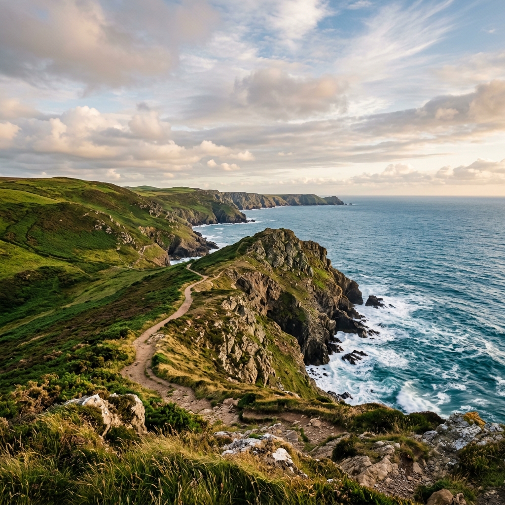
Across the
Llŷn
A remote coastal traverse shaped by exposure and rugged terrain.
Classification
Very Hard
Duration
7 days
Route distance
148.3km
Vertical Gain
+3,112m
Max Altitude
411m
Mission Brief
The Llŷn Peninsula Coastal Path is a remote, culturally distinct segment of the Wales Coast Path, stretching from Caernarfon to Porthmadog.
The route traverses rugged cliffs, expansive sandy bays, and exposed coastal ridges, offering continuous views of the Irish Sea from Caernarfon to Porthmadog.
A remote coastal traverse combining exposed cliff paths, variable terrain, and sustained physical demand.
Mission Snapshot
Intensity Breakdown
Understanding what drives the overall route demand
Physical
72
Technical
17
Commitment
32
Primary driver: Physical load
- Sustained Physical Output
- Significant Vertical Gain
- Multi-day Endurance Load
Advanced multi-day effort: heavy fatigue, logistics, or movement friction—not necessarily alpine exposure.
Full Route Breakdown
Complete stage overview with transparent route metrics. Values are shown as recorded in the route dataset and source links.
Distance
148.3 km
Ascent
3,112 m
Highest point
411 m
Start
Caernarfon
Finish
Porthmadog
Use the KM / MI toggle in the main menu to switch units.
Route Profile
Fixed backcountry campground structure for this route
Route Considerations
This route is generally safe, but these are the main factors to be aware of.
Cliffside Paths
Some sections follow exposed coastal cliffs.
Impact
Moderate
Likelihood
Occasional
Tip
Stay aware of footing, especially in wet or windy conditions.
Changing Weather
Coastal weather can shift quickly, with wind and fog reducing visibility.
Impact
Moderate
Likelihood
Regular
Tip
Check the local forecast before each day and adjust timing if needed.
Limited Signal Coverage
Mobile reception can be unreliable in remote sections.
Impact
Low
Likelihood
Frequent
Tip
Download offline maps before starting each day.
Why hike this route?
COASTAL IMMERSION
Continuous exposure to sea cliffs and open ocean views
PHYSICAL CONSISTENCY
Daily long-distance effort with sustained elevation gain
LOW CROWD DENSITY
Quiet, remote stretches with limited foot traffic
RAW TERRAIN VARIETY
Cliffs, ridgelines, beaches and uneven coastal paths
Expert Verdict
“The physical demand is driven by sustained distance rather than extreme technical difficulty. However, constant exposure to wind and weather makes this route more committing than it appears. Plan conservatively and monitor conditions daily.”
Who This Is For
- COMFORTABLE WITH 15–25KM DAYS - Able to sustain multi-day hiking effort
- OK WITH EXPOSURE - Comfortable walking along cliffs and exposed sections
- NAVIGATION CONFIDENT - Able to handle less-defined paths and remote terrain
- WEATHER RESILIENT - Prepared for rapid coastal weather changes
Plan This Hike
Key things to arrange before starting this route—practical tips first, then buttons that open curated picks (gear, maps, stays) where we list them.
Essential Gear
Recommended preparation for this route:
Day-hike kit: match footwear, layers, and exposure to the route conditions—not just mileage on the map.
- Full-sleeve windproof/waterproof shell
- Sturdy hiking boots with ankle support
- Gaiters (for muddy cliff-top sections)
Stay Connected
Explore accommodation options for this trail:
Mobile signal can fade surprisingly fast once terrain, weather, or local coverage gets in the way.
- Download offline maps before you leave reliable service
- Share your plan and expected return time with someone off-trail
- A charged phone is useful, but only if the route is already stored offline
Getting There
Travel and trail access for this route:
Access is via train to Bangor or Caernarfon (bus connection), and returning from Porthmadog via the Cambrian Coast line. The 'Sherpa' bus network and local Gwy…
- Long-stay parking is available at the start in Caernarfon and at the finish in Porthmadog.
- Area: Llŷn Peninsula (Gwynedd)
- Confirm seasonal road or facility closures before you travel
Where to Stay
Explore accommodation options for this trail:
High density of traditional B&Bs, boutique guesthouses in Abersoch, and well-maintained campgrounds (e.g., at Aberdaron and Nefyn). Wild camping is generally r…
- Book early in busy parks and gateway towns
- Match lodging to how far you want to drive on hike day
- Keep a flexible cancellation buffer when mountain weather is uncertain
Compare This Route
See how this route compares to similar hikes in overall demand and terrain profile.Compare routes by the shape of the effort, not only the headline score.
Albanian Coastal Trail
Closest overall match in demand profile
The Albanian Coastal Trail is a rugged multi-day trek traversing the Ionian...
Intensity
Lower intensityMount Liamuiga
Lower overall intensity, similar terrain type
The Giant of St. Kitts. Mount Liamuiga (1,156m) is a massive stratovolcano ...
Intensity
Lower intensityOrdesa — Cola de Caballo to Refugio de Góriz
Higher physical or technical demand
Ordesa y Monte Perdido is the crown jewel of the Spanish Pyrenees. This ico...
Intensity
Higher intensityExplore Alternatives
Broaden the picture with easier, harder, and nearby options.
Looking for something easier?
Lower intensity — helpful if this route feels like a stretch right now.
Want more challenge?
Higher intensity — for when you are ready for a bigger physical or technical step.
More hikes in this region
Nearby and regionally relevant routes for the next step in your search.
Compare with any route
Pick any hike worldwide and open a full side-by-side comparison.
What You Need to Know
Essential answers about the demands, risks, and logistics of this route.
Q.How hard is this hike really?
Q.Do I need technical gear?
Q.Is water available on the route?
Q.What is the main risk?
Ready to hike the Llŷn Peninsula?
A final decision point after reviewing the route, risks, logistics, and alternatives.
This route is a strong match if you're comfortable with multi-day hiking, moderate physical load (Intensity ~68/100), and exposed coastal conditions.
Build your itinerary, stages, and logistics.
Looking for something easier, more challenging, or a different terrain profile?
Compare routes by intensity, terrain, and region.