The West
Coast Trail
A quota-controlled coastal trek where tide windows, ladder systems, and mud—not altitude—set the daily pace.
Classification
Very Hard
Duration
7 days
Route distance
75.0km
Vertical Gain
+1,813m
Max Altitude
123m
Mission Brief
The West Coast Trail (WCT) is a 75-kilometre coastal trek on the southwestern shore of Vancouver Island, within Pacific Rim National Park Reserve.
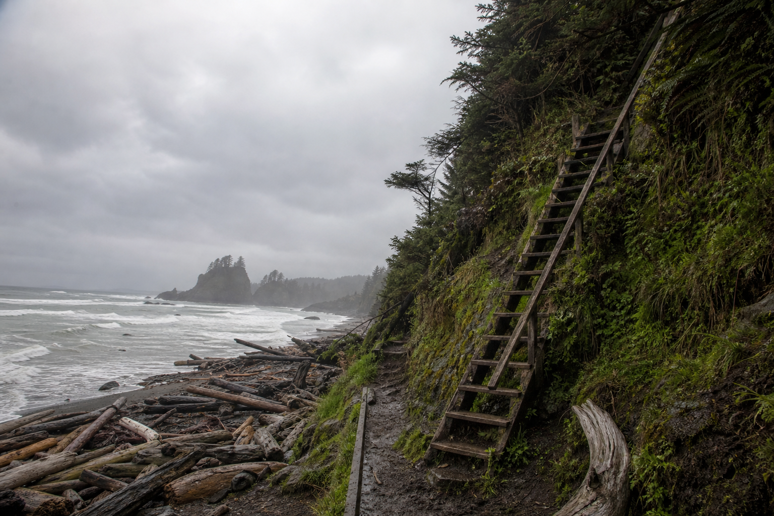
Originally built in 1907 as the 'Dominion Lifesaving Trail' after the SS Valencia shipwreck, the route passes through the ancestral territories of the Huu-ay-aht, Ditidaht, and Pacheedaht First Nations. The terrain alternates between dense temperate rainforest, sandstone tidal shelves, and headland cliffs connected by over 70 wooden ladder systems. Tide tables are essential—several beach sections are only passable at low tide.
Zero cell service; Parks Canada and the Coast Guard coordinate rescue via water taxi or helicopter.
Mission Snapshot
Intensity Breakdown
Understanding what drives the overall route demand
Physical
64
Technical
58
Commitment
82
Primary driver: Commitment and footing friction—not summit altitude or route ambiguity
- Terrain inefficiency (mud, roots, ladders)
- Tidal timing and linear-trail entrapment pressure
- Slow evacuation and no cell coverage
- Sustained wet-footing instability
Advanced multi-day effort: heavy fatigue, logistics, or movement friction—not necessarily alpine exposure.
Full Route Breakdown
Complete stage overview with transparent route metrics. Values are shown as recorded in the route dataset and source links.
Distance
75.0 km
Ascent
1,813 m
Highest point
123 m
Start
Pachena Bay — north terminus (km 0)
Finish
Gordon River — south terminus (km 75)
Use the KM / MI toggle in the main menu to switch units.
Route Profile
Fixed backcountry campground structure for this route
⚠ Cumulative elevation gain understates effort—GPS tracks often exceed the official 75 km, and ladder-and-mud days convert map distance into much slower field pace than a maintained mountain trail.
Operational Reality
Profile axis follows Parks Canada's 75 km corridor with km 0 at Pachena Bay (north) and km 75 at Gordon River (south)—the direction most 7-day itineraries use. You may hike south to north; stage order on the ground reverses. Thirteen official campgrounds have toilets and food lockers (except Orange Juice Creek, km 15). GPS tracks commonly read 85–90 km.
Route Considerations
High injury and entrapment risk: wet ladders, deep mud, and tide-dependent beaches stack consequence even though summit altitude stays low. Rescue is slow without satellite comms.
Slippery terrain and injuries
Slippery roots, deep mud, and wet wooden ladders cause frequent falls and lower-leg injuries. The WCT has a historically high rate of evacuation and lower-leg injuries compared with many maintained Canadian backpacking routes.
Impact
Route-specific
Likelihood
Context-dependent
Tip
Keep pack weight under 18-20kg. Wear waterproof boots with good ankle support and tall gaiters. Take ladders slowly, one person at a time.
Tidal entrapment
Several beaches are only passable at low tide. Owen Point (~km 70) is the famous gatekeeper: plan for a tide below 1.8 m (about 6 ft) using the Tofino table, not Port Renfrew—rising water pins you against sandstone cliffs with no forest exit.
Impact
Route-specific
Likelihood
Context-dependent
Tip
Study the tide table from mandatory orientation (Tofino reference for open-coast sections). Mark forest bypasses before entering tide shelves; never start a restricted beach on a rising tide.
Terrain & conditions
Conditions change quickly on the ground. Slow down on wet rock and pay more attention where paths narrow or exposure increases.
Impact
Moderate
Likelihood
Variable
Tip
Refer to stage notes and expert briefings; maintain focus on slick or exposed sections.
Why hike this route?
LANDSCAPE
The dramatic visual contrast of grey Pacific surges against ancient, emerald-green cedar forests.
VARIETY
The unique experience of camping on wild beaches and observing humpback whales and sea lions from the trail.
CULTURE & PLACE
A sense of connection to both the maritime history of the coast and the living heritage of the Nuu-chah-nulth people.
STANDOUT
Knee-deep in cedar-root mud one moment, wide tidal shelves and whale spouts the next—the WCT is maritime history under your boots, not summit chasing, on Huu-ay-aht, Ditidaht, and Pacheedaht land. The Graveyard of the Pacific nickname is earned: shipwreck lore, sea stacks, and s…
Expert Verdict
“Read the WCT as a friction-and-commitment hike, not a mountainside ascent. Official distance is 75 km, but GPS tracks often run longer; what limits you is tides, ladder bottlenecks with a full pack, and mud that turns a 12 km day into six to nine hours on your feet. It belongs in our Very Hard band—serious coastal backpacking—rather than expedition-grade alpine terrain. Keep pack weight near 18 kg, use synthetic insulation, and do not treat Camper Bay to Gordon River as a casual final day; Parks Canada warns against hiking that block in one push from a fresh start. At Nitinaht Narrows (~km 32), the water taxi and Ditidaht-run Crabshack are cash-first—carry extra for salmon or crab when connectivity is patchy. The trade-off is real: wild beach camps, Huu-ay-aht, Ditidaht, and Pacheedaht territory, maritime history, and no cell service once you leave the trailheads.”
Who This Is For
- ADVANCED — Multi-day wet-coast backpacking; confident carrying a full pack on slick multi-storey ladders and unbridged surge channels with tide tables.
- PHYSICAL — High: 18–20 kg packs on multi-storey ladders and slick roots load knees, shoulders, and ankles under a shifting centre of gravity—expect tired legs every evening.
- WATCH FOR — Over-packing; heavier packs cause more falls on ladders and slippery roots. Keep it under 20kg.
- WATCH FOR — Underestimating how long the muddy southern sections take; budget extra hours.
Plan This Hike
Key things to arrange before starting this route—practical tips first, then buttons that open curated picks (gear, maps, stays) where we list them.
Essential Gear
Recommended preparation for this route:
Coastal rainforest backpacking: mud, ladders, tides, and constant humidity define the kit list.
- Synthetic insulation and a reliable waterproof shell—down stays damp for days
- Tall gaiters, grippy boots, and a pack under 18-20 kg for ladder safety
- Approved food lockers at camps; slips, tides, and hypothermia matter more than wildlife
Stay Connected
Explore accommodation options for this trail:
There is no cell service on the trail; treat communications as a backcountry expedition problem.
- Carry a satellite messenger or PLB—Parks Canada cannot reach you by phone in-canyon
- Download offline maps and your tide table before the mandatory orientation
- Leave a stage plan with ferry dates and intended camp nights with someone at home
Getting There
Travel and trail access for this route:
Linear trail between Bamfield (Pachena Bay) and Port Renfrew (Gordon River)—shuttles from Victoria or Nanaimo are the usual access.
- Book West Coast Trail Express or other shuttle seats early for peak season
- North-to-south (Pachena first) is the usual choice—lighter pack before the southern ladders
- Confirm ferry crossing times and tide windows at mandatory orientation
- Paid parking at both trailheads—managed by local First Nations communities
Where to Stay
Explore accommodation options for this trail:
Designated beach camps only on trail; Bamfield and Port Renfrew handle pre- and post-trail nights.
- Reserve your WCT permit and quota slot as soon as booking opens (often February)
- On trail: pit toilets and shared bear lockers at official camps—no huts or lodges
- Half-trail hikers use the Nitinaht Narrows water taxi mid-point
Compare This Route
See how this route compares to similar hikes in overall demand and terrain profile.Compare routes by the shape of the effort, not only the headline score.
Fraser Island
Closest overall match in demand profile
The K'gari (Fraser Island) Great Walk is an 8-day through-hike covering app...
Intensity
≈ same difficultyAlbanian Coastal Trail
Lower overall intensity, similar terrain type
The Albanian Coastal Trail is a rugged multi-day trek traversing the Ionian...
Intensity
Lower intensityWilderness Coast Walk
Higher physical or technical demand
The Wilderness Coast Walk is a remote, point-to-point coastal trek of rough...
Intensity
Higher intensityExplore Alternatives
Broaden the picture with easier, harder, and nearby options.
Looking for something easier?
Lower intensity — helpful if this route feels like a stretch right now.
Want more challenge?
Higher intensity — for when you are ready for a bigger physical or technical step.
More hikes in this region
Nearby and regionally relevant routes for the next step in your search.
The Rockwall Trail
british-columbia · canada
Distance
54.0 km
Ascent
2,600 m
The East Coast Trail
newfoundland · canada
Distance
336.0 km
Ascent
—
Sunshine Coast Trail
british-columbia · canada
Distance
180.0 km
Ascent
6,000 m
Panorama Ridge
garibaldi-provincial-park-british-columbia · canada
Distance
30.0 km
Ascent
1,520 m
Tonquin Valley
alberta · canada
Distance
44.0 km
Ascent
700 m
Slim’s River West Trail
kluane-national-park-yukon · canada
Distance
45.0 km
Ascent
1,400 m
Compare with any route
Pick any hike worldwide and open a full side-by-side comparison.
What You Need to Know
Essential answers about the demands, risks, and logistics of this route.
Q.How hard is this hike really?
Q.Do I need technical gear?
Q.Is water available on the route?
Q.What is the main risk?
Ready to hike The West Coast Trail?
A final decision point after reviewing the route, risks, logistics, and alternatives.
This route is a strong match if you're comfortable with the effort level implied by an Intensity Score around 67/100 (Very Hard), sustained hiking where this route requires it, and the terrain and exposure described in this guide.
Build your itinerary, stages, and logistics.
Looking for something easier, more challenging, or a different terrain profile?
Compare routes by intensity, terrain, and region.