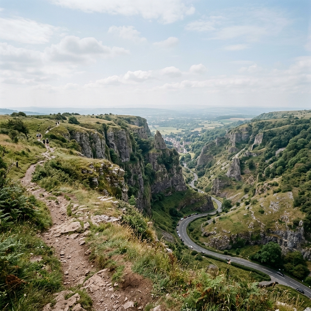
Cheddar Gorge
Circular
England’s largest limestone gorge, with cliffs rising around 120 m above the valley floor.
Classification
Moderate
Duration
2–4 hours
Route distance
6.4km
Vertical Gain
+275m
Max Altitude
254m
Mission Brief
Cheddar Gorge is England’s largest limestone gorge, with soaring cliffs rising around 120 metres above the valley floor.
This short but steep circular loop gains the clifftops quickly for wide views across the Mendip Hills and Somerset Levels, then returns via the opposite rim. The terrain combines polished limestone steps, grassy cliff-top paths, and rougher rocky sections near the pinnacles, with the North Rim descent often feeling slicker than expected.
Unfenced clifftops and variable surface friction (dry grip vs. wet polished stone) make for a high-consequence environment: a simple trip or stumble near the rim can mean an immediate vertical drop, not a bruised knee.
Mission Snapshot
Intensity Breakdown
Understanding what drives the overall route demand
Physical
24
Technical
14
Commitment
12
Primary driver: Steep climbing and exposed cliff-top walking
- Concentrated Elevation Gain
- High Exposure (Unfenced)
- Polished Limestone Terrain
- Micro-terrain friction (polished rock)
Active effort required, but no significant risk. Suitable for recreational hikers.
Full Route Breakdown
Complete stage overview with transparent route metrics. Values are shown as recorded in the route dataset and source links.
Distance
6.4 km
Ascent
275 m
Highest point
254 m
Start
Jacob's Ladder to the Lookout
Finish
The North Rim Return
Use the KM / MI toggle in the main menu to switch units.
Route Profile
Single-night summit push structure
Route Considerations
This route is generally safe, but these are the main factors to be aware of.
Limestone Slip Hazard
Polished limestone steps and worn rock sections become noticeably slippery after rain, especially on steeper descents and around the busiest access points. The Lion Rock-side descent on the North Rim is the section most walkers report as slickest.
Impact
Route-specific
Likelihood
Context-dependent
Tip
Wear footwear with reliable grip, slow down on wet rock, and use adjacent grassy verges where safe instead of committing fully to polished stone.
Unguarded Cliff Edges
Several rim sections run close to unfenced cliff edges, where wind and distraction can quickly reduce your margin for error.
Impact
Route-specific
Likelihood
Context-dependent
Tip
Keep a deliberate line well back from the edge in gusty weather. South Rim pinnacles can feel strongly buffeted in crosswinds.
Surface friction (micro-terrain)
Surface friction is highly variable: dry limestone can feel grippy, but wet limestone is treacherous—polished steps and worn rock add micro-terrain difficulty beyond what a simple elevation profile suggests, requiring constant attention to lateral stability.
Impact
Route-specific
Likelihood
Context-dependent
Tip
Grip-first footwear; shorten stride on steep descents; favour grass verges beside polished stone where safe.
Why hike this route?
LANDSCAPE
The drama of the towering limestone walls and the sweep of the Somerset Levels.
VARIETY
The contrast between steep gorge-side climbing, open cliff-top walking, and rougher limestone sections near the pinnacles.
CULTURE & PLACE
Connection to deep human history (Cheddar Man) and local heritage.
STANDOUT
The clifftop perspective. Few short English walks give such an immediate sense of height: steep limestone walls below, open grassland above, and long views out across the Somerset Levels.
Expert Verdict
“Cheddar Gorge is a short route, but not a throwaway one. The steep climbing, polished limestone, and exposed clifftops give it more bite than the mileage suggests, especially in wind or after rain.”
Who This Is For
- MODERATE — Active walkers comfortable with steep gradients and constant cliff-edge proximity. No scrambling skills needed.
- PHYSICAL — Concentrated. The route is short, but the opening climb and the second ascent on the return make it feel steeper than many walkers expect.
- WATCH FOR — Ending the hike with the North Rim descent without factoring in how steep and slick it can feel, especially in damp weather.
- WATCH FOR — Not checking whether your chosen ascent line involves paid access or a nearby free public alternative.
Plan This Hike
Key things to arrange before starting this route—practical tips first, then buttons that open curated picks (gear, maps, stays) where we list them.
Essential kit
Recommended preparation for this route:
A short route on paper, but the polished limestone and exposed rim make footwear and weather layers matter.
- Wear boots or shoes with confident grip on wet rock
- Carry a windproof layer for the exposed rims
- Take offline mapping even though the route is short
Signal and navigation
Stay reachable and oriented in the field:
Mobile signal is usually decent on the rims, but do not rely on it completely in the gorge itself.
- Download offline maps before leaving the village
- Mist, rain, and busy foot traffic make it easier to miss turns than the distance suggests
- A charged phone is enough for most walkers, but only if the route is already stored offline
Getting there
Travel and trail access for this route:
Cheddar Village is an easy base, but parking, crowds, and your chosen ascent line all shape the start of the walk.
- Use village or gorge car parks and check opening times
- Decide in advance whether you want the paid Jacob's Ladder line or the free public-path alternative
- Arrive earlier on weekends and holidays to avoid the busiest start window
Stay nearby
Explore accommodation options for this trail:
Cheddar works well as a relaxed base if you want to walk early or avoid the day-trip peak.
- Cheddar Village has B&Bs, inns, and campsites close to the route
- An overnight stay makes early starts easier in summer
- Book ahead on bank-holiday weekends
Compare This Route
See how this route compares to similar hikes in overall demand and terrain profile.Compare routes by the shape of the effort, not only the headline score.
Route des Crêtes & Cap Canaille
Closest overall match in demand profile
Cap Canaille, situated between the charming ports of Cassis and La Ciotat, ...
Intensity
Higher intensityKrimml Waterfalls — The Vertical Mist
Lower overall intensity, similar terrain type
The Krimml Waterfalls are the tallest in Europe, dropping 380 meters in thr...
Intensity
Lower intensityIbón de Escarpinosa — The Sapphire of Benasque
Higher physical or technical demand
Hidden in the Estós Valley near Benasque, the Ibón de Escarpinosa is often ...
Intensity
Higher intensityExplore Alternatives
Broaden the picture with easier, harder, and nearby options.
Looking for something easier?
Lower intensity — helpful if this route feels like a stretch right now.
Want more challenge?
Higher intensity — for when you are ready for a bigger physical or technical step.
More hikes in this region
Nearby and regionally relevant routes for the next step in your search.
Baggy Point Circular
Devon, England · united-kingdom
Distance
16.0 km
Ascent
260 m
Lizard Point to Kynance Cove
Cornwall, England · united-kingdom
Distance
8.0 km
Ascent
273 m
Tregennis Coastal Walk
Pembrokeshire, Wales · united-kingdom
Distance
9.6 km
Ascent
160 m
Woolacombe to Ilfracombe Coast
North Devon, England · united-kingdom
Distance
16.0 km
Ascent
515 m
Tintagel to Boscastle Coastal Walk
Cornwall, England · united-kingdom
Distance
8.5 km
Ascent
400 m
Barafundle Bay & Stackpole Estate
Pembrokeshire, Wales · united-kingdom
Distance
9.6 km
Ascent
182 m
Compare with any route
Pick any hike worldwide and open a full side-by-side comparison.
What You Need to Know
Essential answers about the demands, risks, and logistics of this route.
Q.How hard is this hike really?
Q.Do I need technical gear?
Q.Is water available on the route?
Q.What is the main risk?
Ready to hike Cheddar Gorge Circular?
A final decision point after reviewing the route, risks, logistics, and alternatives.
This route is a strong match if you're comfortable with the effort level implied by an Intensity Score around 32/100 (Moderate), sustained hiking where this route requires it, and the terrain and exposure described in this guide.
Build your itinerary, stages, and logistics.
Looking for something easier, more challenging, or a different terrain profile?
Compare routes by intensity, terrain, and region.