Amatola Hiking
Trail
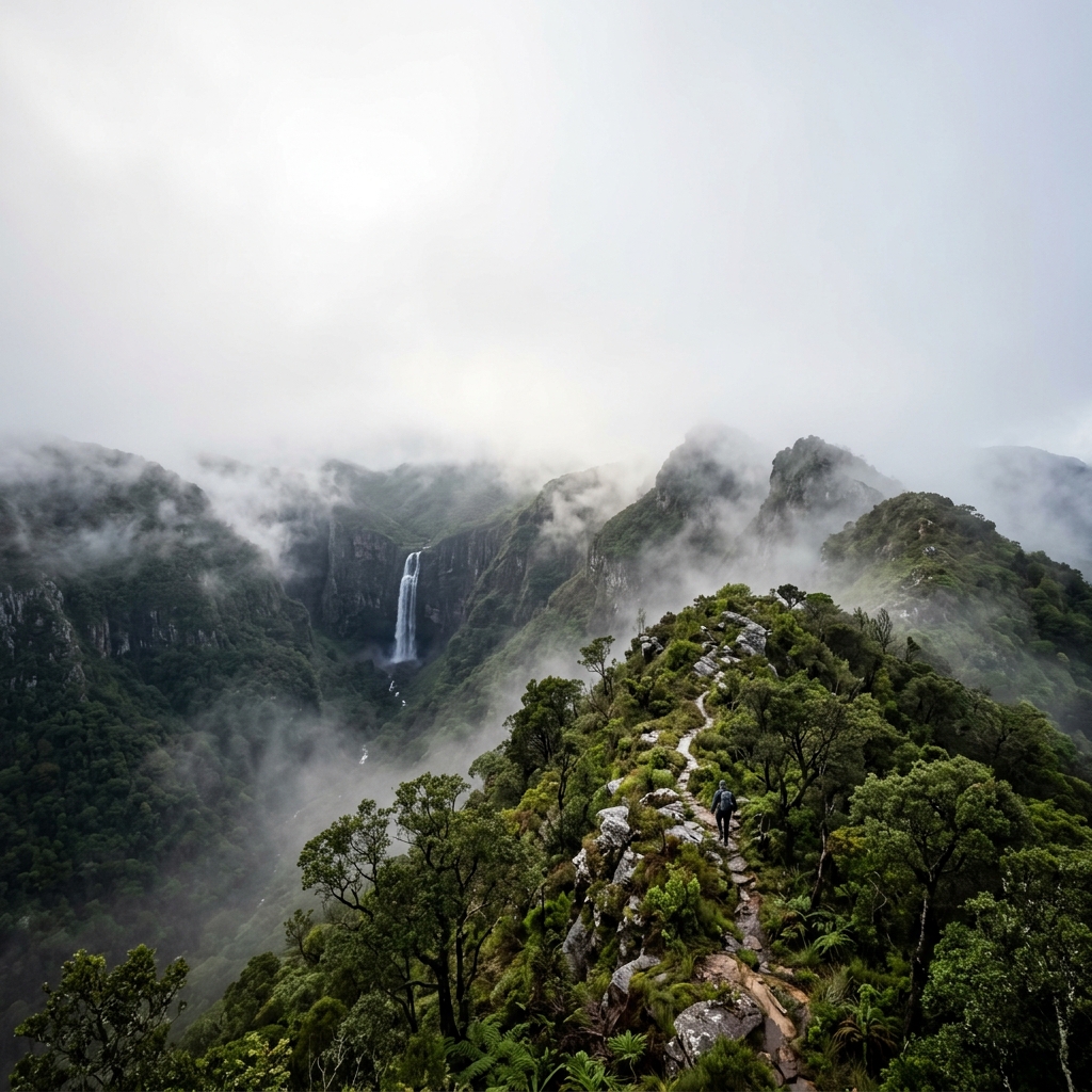
Often regarded as one of South Africa’s toughest multi-day hikes, this is a relentlessly hard hut-to-hut route through ancient Afromontane forest.
Classification
Very Hard
Duration
6 days
Route distance
101.8km
Vertical Gain
+5,000m
Max Altitude
1,880m
Mission Brief
Often regarded as one of South Africa’s toughest multi-day hikes, the Amatola Trail is a relentlessly demanding hut-to-hut journey through ancient Afromontane forest in the Eastern Cape.
A hard six-day route with roughly 100 km of walking and about 4,900–5,000 m of climbing, it moves through dense yellowwood forest, deep valleys, open ridgelines, and numerous waterfalls and cascades. Trails are often wet and uneven, with roots, mud, and repeated steep descents slowing progress.
What defines the Amatola is not technical climbing but cumulative punishment. Flat sections are brief, the hut system fixes your stages, and the trail steadily grinds people down through repeated ascent, descent, wet feet, and heavy-pack fatigue.
Choose the Amatola if you want one of South Africa’s hardest hutted hikes - not because it is technical, but because six fixed stages of mud, steep descents, wet feet, and repeated climbs wear people down.
Mission Snapshot
Intensity Breakdown
Understanding what drives the overall route demand
Physical
80
Technical
43
Commitment
73
Primary driver: Physical load
- Cumulative fatigue across fixed hut stages
- Wet terrain and poor footing multiply effort
- Remote commitment with limited exit options
- Heavy pack penalty on steep climbs and descents
Advanced multi-day effort: heavy fatigue, logistics, or movement friction—not necessarily alpine exposure.
Full Route Breakdown
Complete stage overview with transparent route metrics. Values are shown as recorded in the route dataset and source links.
Distance
101.8 km
Ascent
5,000 m
Highest point
1,880 m
Start
Maden Dam
Finish
Tyume River / Hogsback
Use the KM / MI toggle in the main menu to switch units.
Route Profile
Fixed backcountry campground structure for this route
Route Considerations
This route is generally safe, but these are the main factors to be aware of.
Weather is the defining risk factor
Dense mist can reduce visibility to near zero, especially on ridgelines. Heavy rainfall turns trails into mud channels, increases slip risk on roots and rock, and can effectively push the route a full difficulty tier higher than in dry weather.
Impact
Route-specific
Likelihood
Context-dependent
Tip
Do not attempt the high ridges without a fully charged GPS and physical maps. Familiarize yourself with the yellow footprint trail markers, which can be obscured by low-hanging moss ('Old Man's Beard'), and treat wet-weather pace estimates as substantially slower.
Physical and Psychological Load
Relentless vertical repetition and long hours in monotone, dense forest can feel disorienting. Slower progress than expected is common, especially once cumulative fatigue sets in from day 3 onward.
Impact
Route-specific
Likelihood
Context-dependent
Tip
Utilize trekking poles for all forest stages. Maintain a steady, conservative pace; knees are the first to fail on the steep forest descents, especially when carrying a heavier multi-day pack.
River crossings after rain
Minor river crossings are part of the trail, and some stream crossings become slower and more awkward after heavy rain, especially in the forested valleys.
Impact
Route-specific
Likelihood
Context-dependent
Tip
Allow extra time after wet weather, unbuckle your pack when needed, and do not assume every crossing will feel the same as the previous one.
Why hike this route?
LANDSCAPE
The mystical Afromontane forests - often compared to Tolkien's Middle Earth - with ancient yellowwoods, mist, and moss-covered waterfalls.
VARIETY
The shift from deep, humid river valleys and waterfall forest to open ridgelines, rock pools, and broad Eastern Cape views.
CULTURE & PLACE
Ending the trek in the eccentric, fairy-tale-themed mountain village of Hogsback.
WHY GO
Choose the Amatola if you want one of South Africa’s hardest hutted hikes - not because it is technical, but because six fixed stages of mud, steep descents, wet feet, and repeated climbs wear people down.
Expert Verdict
“The Amatola Hiking Trail is not technically extreme, but it is one of the clearest examples of cumulative physical and mental attrition in the catalog. With about 5,000 m of climbing, wet terrain, fixed hut stages, and six days of uninterrupted load carrying, it deserves a harder reading than a standard severe multi-day hike.”
Who This Is For
- ADVANCED — Experienced hikers comfortable with sustained elevation gain, cumulative fatigue, heavy pack carry, minor river crossings, and navigation in low-visibility conditions.
- PHYSICAL — Extremely High. The route is not broken by big alpine passes so much as by repeated steep climbing, wet descents, slippery roots, and the way fatigue compounds from day 3 onward.
- WATCH FOR — Starting too hard on days 1-2 and finding that the real collapse comes on days 3-5.
- WATCH FOR — Letting feet stay wet for days and then losing pace once blisters, cold, and fatigue start combining.
Plan This Hike
Key things to arrange before starting this route—practical tips first, then buttons that open curated picks (gear, maps, stays) where we list them.
Essential Gear
Recommended preparation for this route:
Day-hike kit: match footwear, layers, and exposure to the route conditions—not just mileage on the map.
- Footwear with maximum traction (wet forest grip)
- Heavy-duty gaiters for mud, wet grass, and thorny sections
- Significant rain protection (gore-tex shell + gaiters)
Stay Connected
Explore accommodation options for this trail:
Mobile signal can fade surprisingly fast once terrain, weather, or local coverage gets in the way.
- Download offline maps before you leave reliable service
- Share your plan and expected return time with someone off-trail
- A charged phone is useful, but only if the route is already stored offline
Getting There
Travel and trail access for this route:
The trail is a point-to-point route starting at **Maden Dam** (near King William’s Town / Qonce) and finishing in **Hogsback**. Closest airport: East London (E…
- Long-term parking is best arranged in Hogsback; shuttles then drop hikers at the Maden Dam trailhead.
- Area: Eastern Cape / Amathole Mountains
- Confirm seasonal road or facility closures before you travel
Where to Stay
Explore accommodation options for this trail:
Strictly limited to the fixed 5-hut overnight structure: Gwili Gwili → Dontsa → Cata → Mnyameni → Zingcuka. No wild camping allowed, and the hut system fixes t…
- Book early in busy parks and gateway towns
- Match lodging to how far you want to drive on hike day
- Keep a flexible cancellation buffer when mountain weather is uncertain
Compare This Route
See how this route compares to similar hikes in overall demand and terrain profile.Compare routes by the shape of the effort, not only the headline score.
The Queyras Tour
Closest overall match in demand profile
The Tour du Queyras (GR58) is a spectacular 120km loop traversing the remot...
Intensity
Lower intensityOrdesa — Cola de Caballo to Refugio de Góriz
Lower overall intensity, similar terrain type
Ordesa y Monte Perdido is the crown jewel of the Spanish Pyrenees. This ico...
Intensity
Lower intensityCordillera Apolobamba Traverse
Higher physical or technical demand
The Apolobamba Traverse is a remote, high-altitude backpacking route in the...
Intensity
Higher intensityExplore Alternatives
Broaden the picture with easier, harder, and nearby options.
Looking for something easier?
Lower intensity — helpful if this route feels like a stretch right now.
Want more challenge?
Higher intensity — for when you are ready for a bigger physical or technical step.
Vale do Pati
chapada-diamantina · brazil
Distance
40.0 km
Ascent
2,500 m
Mount Nyiragongo Lava Lake Trek
Virunga National Park (UNESCO World Heritage Site) · Democratic Republic of the Congo
Distance
16.0 km
Ascent
1,500 m
Kangchendzonga Himal
taplejung-eastern-nepal · nepal
Distance
200.0 km
Ascent
5,500 m
More hikes in this region
Nearby and regionally relevant routes for the next step in your search.
Northern Drakensberg Amphitheatre
kwazulu-natal · south-africa
Distance
12.0 km
Ascent
600 m
The Hoerikwaggo Trail
western-cape · south-africa
Distance
75.0 km
Ascent
2,800 m
Kruger Wilderness Trails
mpumalanga-limpopo · south-africa
Distance
30.0 km
Ascent
50 m
The Otter Trail
garden-route · south-africa
Distance
42.0 km
Ascent
2,200 m
Table Mountain
western-cape · south-africa
Distance
3.0 km
Ascent
800 m
Compare with any route
Pick any hike worldwide and open a full side-by-side comparison.
What You Need to Know
Essential answers about the demands, risks, and logistics of this route.
Q.How hard is this hike really?
Q.Do I need technical gear?
Q.Is water available on the route?
Q.What is the main risk?
Ready to hike Amatola Hiking Trail?
A final decision point after reviewing the route, risks, logistics, and alternatives.
This route is a strong match if you're comfortable with the effort level implied by an Intensity Score around 78/100 (Very Hard), sustained hiking where this route requires it, and the terrain and exposure described in this guide.
Build your itinerary, stages, and logistics.
Looking for something easier, more challenging, or a different terrain profile?
Compare routes by intensity, terrain, and region.
Data: official trail documentation and topographic sources · About