Sulphur
Skyline
From the trailhead at Miette Hot Springs, the hike wastes no time easing you in—it is a vertical grind through dense forest from the first step.
Classification
Moderate
Duration
3–5 hours
Route distance
8.0km
Vertical Gain
+700m
Max Altitude
2,050m
Mission Brief
The hike to the summit of Sulphur Skyline is a pure test of steady cardiovascular rhythm.
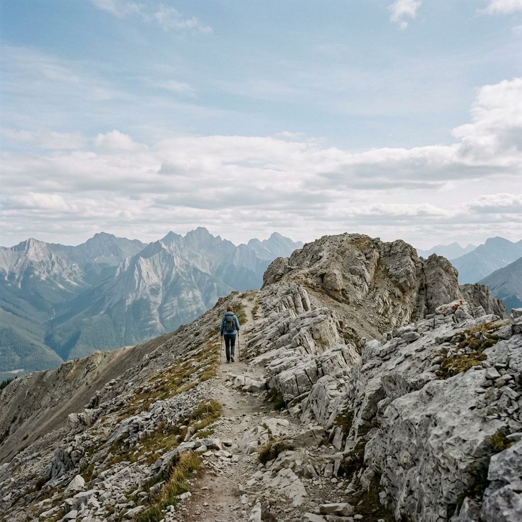
Spanning 4km of relentless uphill on the ascent, the trail pushes through thick lodgepole pine where the only reprieve is the occasional glimpse of the Fiddle Valley through the branches. Upon breaking the treeline, the terrain transforms into a stark, wind-swept alpine ridge that offers an unobstructed 360-degree overlook of the jagged Ashlar Ridge and the vast Jasper wilderness beyond. The experience is framed by a uniquely Canadian luxury: finishing the descent at the very doorstep of the Miette Hot Springs mineral pools.
The terrain transforms as you break the treeline, revealing a expansive ridge where the wind picks up and the scenery shifts from forest to sheer rock.
Mission Snapshot
Intensity Breakdown
Understanding what drives the overall route demand
Physical
38
Technical
24
Commitment
11
Primary driver: Sustained grinding ascent, ridge exposure, and elevation on a short clock
- Sustained steep climbing
- High gain per kilometre on a short return
- Summit ridge exposure and fast-changing mountain weather
- Dense alpine workload in a day-hike format
Active effort required, but no significant risk. Suitable for recreational hikers.
Full Route Breakdown
Complete stage overview with transparent route metrics. Values are shown as recorded in the route dataset and source links.
Distance
8.0 km
Ascent
700 m
Highest point
2,050 m
Start
Miette Hot Springs Start
Finish
Return Descent
Use the KM / MI toggle in the main menu to switch units.
Route Profile
Single-night summit push structure
Route Considerations
This route is generally safe, but these are the main factors to be aware of.
Relentless cardiovascular load
The trail gains 700m in just 4km. There are virtually no flat sections to recover your breath.
Impact
Route-specific
Likelihood
Context-dependent
Tip
Set a steady, slow pace from the start; use trekking poles to save your knees on the steep descent.
Severe summit wind chill
The peak is a natural funnel for mountain winds. It can feel noticeably colder and windier than the trailhead. Thermal comfort at the Miette Hot Springs side can lull you into under-layering for the exposed ridge, even in sunshine.
Impact
Route-specific
Likelihood
Context-dependent
Tip
Carry a high-quality wind shell and summit insulation even on hot valley days; secure loose gear before the treeline and assume ridge winds you cannot feel from the car park.
Bear activity
Grizzly and black bears in the Miette corridor are apex hazards—lethal surprise risk where berry patches and trail traffic concentrate animals. In late-summer berry season, dense bush along the lower switchbacks can create surprise-encounter risk. This is not a “nuisance wildlife” problem like food raids at a hut; treat bear protocols as life-safety, not et…
Impact
Route-specific
Likelihood
Context-dependent
Tip
Carry bear spray within immediate reach; make active noise in forested sections rather than relying on passive awareness; hike in groups; treat the treeline transition as high-consequence for surprise encounters.
Why hike this route?
LANDSCAPE
360-degree views of Ashlar Ridge and the Fiddle Valley below.
VARIETY
The contrast of dark pine forest and stark, wind-blasted alpine skyline.
CULTURE & PLACE
A classic Jasper day: climb a peak, soak in mineral pools.
STANDOUT
The efficiency of the payoff and the post-trail soak. Unlike most mountain trails that have 'benches' or flat recovery zones, Sulphur Skyline is a pure, sustained pitch from first step to final ridge. The x-factor is the transition from a wind-blasted 2050m summit with views of…
Expert Verdict
“A short but relentless 700m climb with no flat sections, leading to one of the most efficient 360° panoramas in Jasper. Expect strong wind exposure above the treeline and a steady grind throughout — rewarded with a soak at Miette Hot Springs. Don’t stop at the false summit; the best views lie further along the ridge.”
Who This Is For
- INTERMEDIATE — Suitable for fit hikers seeking one of the most efficient summit viewpoints in the Rockies. Expect a relentless series of tight switchbacks with zero flat zones for recovery.
- PHYSICAL — High for a half-day effort. A consistently steep double-digit gradient that punishes those who start too fast.
- WATCH FOR — Stopping at the 'False Summit' rather than pushing to the true 2050m peak.
- WATCH FOR — Starting too fast on the relentless lower forested switchbacks.
Plan This Hike
Key things to arrange before starting this route—practical tips first, then buttons that open curated picks (gear, maps, stays) where we list them.
Essential Gear
Recommended preparation for this route:
Short but steep alpine day hike with serious summit exposure.
- Lightweight wind shell for the exposed peak
- Bear spray (mandatory carry in Miette Valley)
- Swimsuit and towel for the post-trail soak
Stay Connected
Explore accommodation options for this trail:
Deceptive coverage; expect dead zones in the lower forest switchbacks.
- Offline maps: Parks Canada or AllTrails recommended
- Emergency: Cell signal usually available at the summit
- Power: Cold and wind exposure can impact battery life
Getting There
Travel and trail access for this route:
Miette Road is a winding 17km mountain road off Highway 16.
- 60km (45 min) drive East from Jasper town
- Start/Finish: Miette Hot Springs Parking (1350m)
- Note: Miette Road is seasonal (May to Oct only)
Where to Stay
Explore accommodation options for this trail:
Base yourself in Jasper town or the nearby Fiddle Valley campgrounds.
- Jasper Townsite: Diverse hotels, hostels, and B&Bs
- Pocahontas Campground: Closest to the trailhead
- Expect heavy foot traffic in summer; book stays early
Compare This Route
See how this route compares to similar hikes in overall demand and terrain profile.Compare routes by the shape of the effort, not only the headline score.
Dachstein Krippenstein — The 5 Fingers & Alpine Shark
Closest overall match in demand profile
High above the UNESCO World Heritage village of Hallstatt, the Krippenstein...
Intensity
Lower intensitySierra Negra Volcano & Volcán Chico
Lower overall intensity, similar terrain type
Sierra Negra Volcano Hike Galápagos. Sierra Negra is a massive shield volca...
Intensity
Lower intensityTiger Fern Trail
Higher physical or technical demand
A strenuous jungle route within the Cockscomb Basin Wildlife Sanctuary. The...
Intensity
Higher intensityExplore Alternatives
Broaden the picture with easier, harder, and nearby options.
Looking for something easier?
Lower intensity — helpful if this route feels like a stretch right now.
Want more challenge?
Higher intensity — for when you are ready for a bigger physical or technical step.
More hikes in this region
Nearby and regionally relevant routes for the next step in your search.
The Grouse Grind
british-columbia · canada
Distance
2.9 km
Ascent
853 m
Lake Agnes Tea House
lake-louise-banff-national-park-alberta · canada
Distance
7.4 km
Ascent
400 m
Berg Lake Trail
british-columbia · canada
Distance
42.0 km
Ascent
800 m
Skyline Trail
alberta · canada
Distance
44.1 km
Ascent
1,400 m
Tonquin Valley
alberta · canada
Distance
44.0 km
Ascent
700 m
Panorama Ridge
garibaldi-provincial-park-british-columbia · canada
Distance
30.0 km
Ascent
1,520 m
Compare with any route
Pick any hike worldwide and open a full side-by-side comparison.
What You Need to Know
Essential answers about the demands, risks, and logistics of this route.
Q.How hard is this hike really?
Q.Do I need technical gear?
Q.Is water available on the route?
Q.What is the main risk?
Ready to hike Sulphur Skyline?
A final decision point after reviewing the route, risks, logistics, and alternatives.
This route is a strong match if you're comfortable with the effort level implied by an Intensity Score around 35/100 (Moderate), sustained hiking where this route requires it, and the terrain and exposure described in this guide.
Build your itinerary, stages, and logistics.
Looking for something easier, more challenging, or a different terrain profile?
Compare routes by intensity, terrain, and region.