Acatenango
Volcano
Two-day rhythm from Antigua: shuttle to La Soledad, then a sustained climb with no flat recovery.
Classification
Very Hard
Duration
2 days
Route distance
16.0km
Vertical Gain
+1,576m
Max Altitude
3,976m
Mission Brief
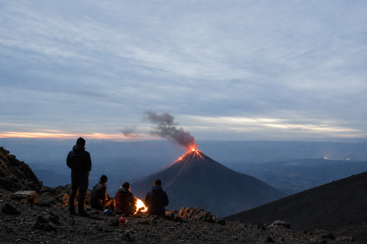
Acatenango (3,976 m) is Guatemala’s classic two-day volcano trek: a sustained climb from La Soledad through farmland and cloud forest to a cold ridge camp facing Volcán de Fuego, then a pre-dawn summit push over loose volcanic cinder.
It is not technical climbing—it is an unrelenting vertical cardio test with almost no flat recovery zones: altitude, thermal whiplash, carrying 4 L+ of water, and sleeping above 3,600 m while an active volcano erupts across the valley.
No water above the trailhead village—carry 4 L+ for the overnight; dehydration amplifies altitude stress.
Mission Snapshot
Intensity Breakdown
Understanding what drives the overall route demand
Physical
77
Technical
48
Commitment
58
Primary driver: Two-day volcanic summit load
- 16 km round trip with +1,500 m and a pre-dawn cinder summit
- Ridge camp cold, wind, and sleep debt near 3,600 m
- No water on the mountain—4 L+ carry from La Soledad
- Long cinder descent on tired legs after summit
Very Hard reflects a two-day volcanic summit mission, not a month-long trek. Acatenango is often guide-supported and logistically streamlined from Antigua—less remote than WCT, GDT, or Akshayuk—but ridge cold, altitude, water carry, sleep debt, and cinder underfoot are genuinely demanding. This band means multi-stage vertical load and thermal exposure, not expedition isolation.
Full Route Breakdown
Complete stage overview with transparent route metrics. Values are shown as recorded in the route dataset and source links.
Distance
16.0 km
Ascent
1,576 m
Highest point
3,976 m
Start
La Soledad (village trailhead / visitor area)
Finish
La Soledad
Use the KM / MI toggle in the main menu to switch units.
Route Profile
Multi-day stage structure
Operational Reality
Modeled on the common La Soledad overnight (~16 km round trip, ~1,550 m gain): 6.5 km to camp + 1.5 km summit spur + 8 km descent (stage 2 = evening at camp, 0 km). Up and down are the same horizontal band (~8 km each way to/from the summit). Many blogs quote 12–14 km or 18–19 km when routes, camps, or optional Fuego side trips differ—see Sources. Not survey-grade GPS.
Volcanic vs wilderness corridor
How this Very Hard volcano mission differs from a classic wilderness corridor (e.g. West Coast Trail ~67 on our index).
Route Considerations
High altitude and cold exposure at camp and summit; no water on the ridge; partial cell coverage only. Volcanic ash and wind from Fuego can worsen conditions—operators monitor INSIVUMEH and may cancel when activity thresholds are exceeded.
High altitude and cold exposure
Summit and ridge temperatures can drop to −5°C with wind chill while the trailhead starts warm and humid.
Impact
Route-specific
Likelihood
Context-dependent
Tip
Pack a full winter kit for camp and summit; acclimatize in Antigua; use ridge shelters or a rated sleeping bag.
Volcanic ash and sulfur
Wind can carry ash and gases from Fuego toward the Acatenango ridge.
Impact
Route-specific
Likelihood
Context-dependent
Tip
Carry a buff or mask; follow guide and INSIVUMEH guidance; keep the tent zipped in windy ash.
Altitude and dehydration
Ridge camp at ~3,600 m with no natural water on the mountain.
Impact
Route-specific
Likelihood
Context-dependent
Tip
Hydrate aggressively; spend two nights near 1,500 m in Antigua before starting; descend if AMS symptoms worsen.
Why hike this route?
LANDSCAPE
Farmland, cloud forest, then a Martian cinder cone above a glowing active volcano.
VARIETY
Biological zones change hour by hour from the trailhead to the ridge.
CULTURE & PLACE
Shared camp energy while waiting for the next Fuego eruption.
STANDOUT
From a wind-blasted ridge at 3,600 m, Fuego’s eruptions light the valley every few minutes—few campsites in the Americas match that raw spectacle.
Expert Verdict
“Acatenango rewards preparation for cold and water more than technical skill. Rent insulation in Antigua, acclimatize, and treat the cinder descent as the hidden knee test after a short night.”
Who This Is For
- ADVANCED FITNESS — Fit hikers comfortable with steep sustained climbing, cold ridge camping, and a pre-dawn cinder push—not technical rope work.
- PHYSICAL — High: +1,500 m with a heavy water carry and no flat recovery on day one; summit cinder on sleep debt.
- WATCH FOR — Underestimating ridge cold—valley T-shirts do not work at 3,600 m.
- WATCH FOR — Carrying too little water—dehydration worsens AMS symptoms.
Plan This Hike
Key things to arrange before starting this route—practical tips first, then buttons that open curated picks (gear, maps, stays) where we list them.
Essential Gear
Recommended preparation for this route:
Two-day volcanic trek—ridge cold, loose cinder, and zero water above the trailhead.
- 4 L+ water, winter layers, rated sleeping bag (rent in Antigua if needed)
- Headlamp, buff/mask for ash, trekking poles for the cinder descent
- Broken-in boots with grip on sand-like cinder
Stay Connected
Explore accommodation options for this trail:
Partial coverage only—treat phones as backup, not safety.
- Download offline maps before leaving Antigua
- Share agency shuttle times and expected return with your hotel
- Assume no reliable signal at ridge camp
Getting There
Travel and trail access for this route:
Antigua is the hub; La Soledad is the standard trailhead.
- Book agency shuttle or taxi for early-morning departures
- Pay/register CONAP fee at trailhead or via operator
- Acclimatize two nights in Antigua when possible
Where to Stay
Explore accommodation options for this trail:
Sleep in Antigua before and after—ridge shelters are basic.
- Reserve Antigua lodging for pre-dawn shuttle days
- Confirm whether your package includes ridge shelter or tent
- Dry base layer for sweaty climb and cold camp
Compare This Route
See how this route compares to similar hikes in overall demand and terrain profile.Compare routes by the shape of the effort, not only the headline score.
Volcán Tajumulco
Closest overall match in demand profile
Touching the ceiling of Central America. Volcán Tajumulco is a massive, ext...
Intensity
Slightly higher intensityWilderness Coast Walk
Lower overall intensity, similar terrain type
The Wilderness Coast Walk is a remote, point-to-point coastal trek of rough...
Intensity
Lower intensityVictoria Peak Trail
Higher physical or technical demand
Belize's most demanding multi-day trek. Over three to four days you cover 2...
Intensity
Higher intensityExplore Alternatives
Broaden the picture with easier, harder, and nearby options.
Looking for something easier?
Lower intensity — helpful if this route feels like a stretch right now.
Want more challenge?
Higher intensity — for when you are ready for a bigger physical or technical step.
More hikes in this region
Nearby and regionally relevant routes for the next step in your search.
Compare with any route
Pick any hike worldwide and open a full side-by-side comparison.
What You Need to Know
Essential answers about the demands, risks, and logistics of this route.
Q.How hard is this hike really?
Q.Do I need technical gear?
Q.Is water available on the route?
Q.What is the main risk?
Ready to hike Acatenango Volcano?
A final decision point after reviewing the route, risks, logistics, and alternatives.
This route is a strong match if you're comfortable with the effort level implied by an Intensity Score around 77/100 (Very Hard), sustained hiking where this route requires it, and the terrain and exposure described in this guide.
Build your itinerary, stages, and logistics.
Looking for something easier, more challenging, or a different terrain profile?
Compare routes by intensity, terrain, and region.