Berg Lake
Trail
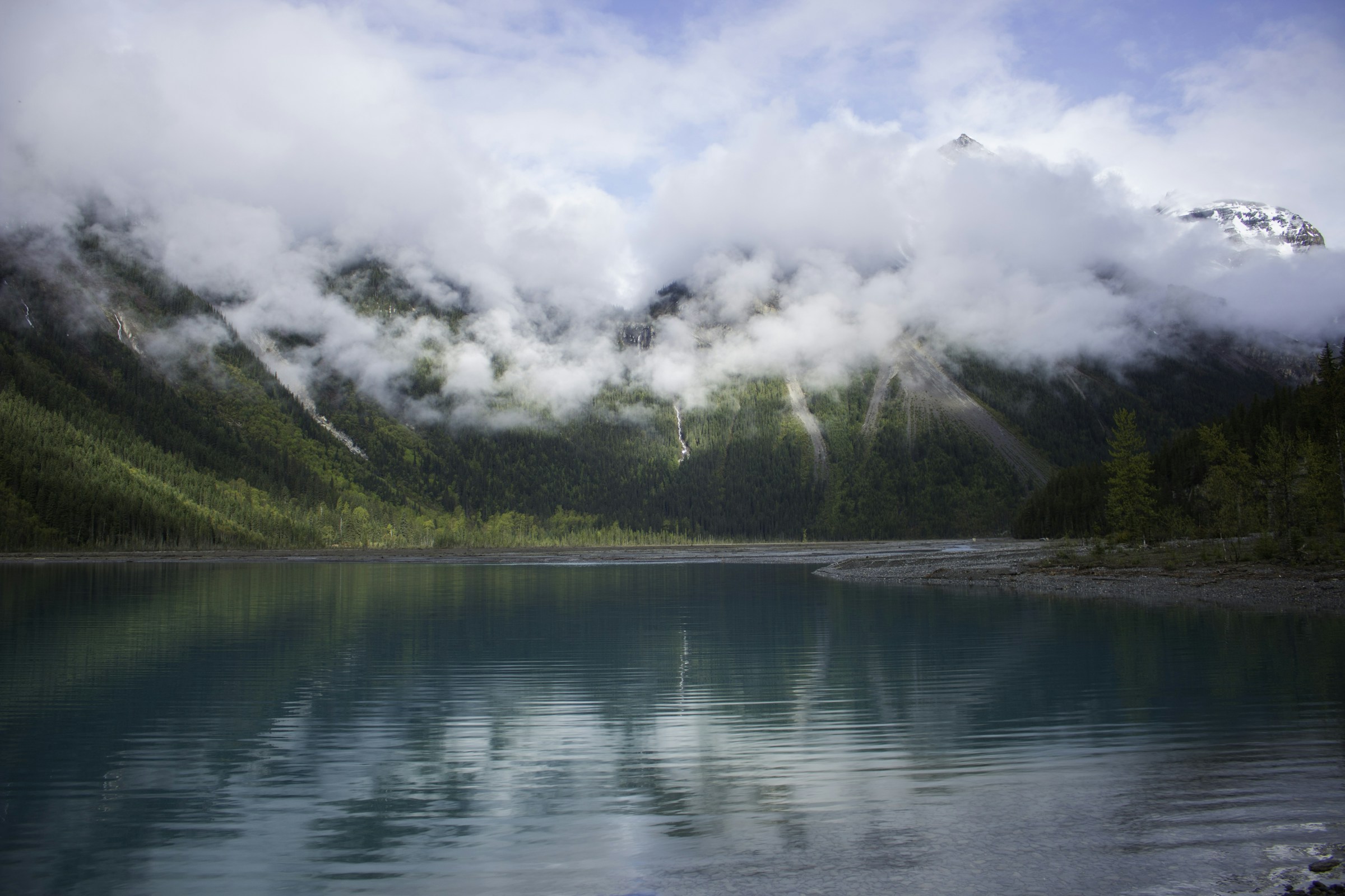
Walking in the shadow of the King.
Classification
Hard
Duration
3 days
Route distance
42.0km
Vertical Gain
+800m
Max Altitude
1,645m
Mission Brief
Walking in the shadow of the King.
The Berg Lake Trail in Mount Robson Provincial Park is a journey to the base of the highest peak in the Canadian Rockies (3954m). The trail takes you through the Valley of a Thousand Waterfalls before reaching the surreal, ice-choked waters of Berg Lake. Here, the massive Berg Glacier tumbles directly into the turquoise water, frequently 'calving' with a roar that echoes against the mountain walls.
The Glacial Calving. At the edge of Berg Lake, you can witness the dynamic movement of the Berg Glacier. Massive chunks of blue ice break off the glacier face and crash into the turquoise water—a sensory experience of s…
Mission Snapshot
Intensity Breakdown
Understanding what drives the overall route demand
Physical
61
Technical
28
Commitment
55
Primary driver: Physical load and campsite logistics—not trailless wilderness isolation
- Sustained physical output on a staged backcountry corridor
- Managed backcountry commitment on a flagship BC Parks route
- Multi-day pacing with glacier-adjacent weather variability
- Permit and reservation logistics as real trip friction
Serious physical effort or sustained terrain friction. Demanding but not expedition-scale.
Full Route Breakdown
Complete stage overview with transparent route metrics. Values are shown as recorded in the route dataset and source links.
Distance
42.0 km
Ascent
800 m
Highest point
1,645 m
Start
Berg Lake Trailhead / Mount Robson Welcome Centre
Finish
Berg Lake / return trailhead
Use the KM / MI toggle in the main menu to switch units.
Route Profile
Multi-day stage structure
Route Considerations
This route is generally safe, but these are the main factors to be aware of.
Flooding
Trail sections remain prone to washouts from glacier melt and heavy rain; the 2021 flood damage has been fully repaired with updated bridges and rerouted, climate-resilient trail beds—still verify BC Parks status each season.
Impact
Route-specific
Likelihood
Context-dependent
Tip
Always check current trail status on BC Parks website; respect all 'Closed' signage; be prepared for high water in early season.
Topographical exposure
The trail climbs rapidly through several climate zones.
Impact
Route-specific
Likelihood
Context-dependent
Tip
Carry layers for freezing temperatures, even in July; be aware of sun exposure near the snowline.
Terrain & conditions
Conditions change quickly on the ground. Slow down on wet rock and pay more attention where paths narrow or exposure increases.
Impact
Moderate
Likelihood
Variable
Tip
Refer to stage notes and expert briefings; maintain focus on slick or exposed sections.
Why hike this route?
LANDSCAPE
The 'Emperor' face of Mount Robson, glowing white glaciers, and neon-blue lakes.
VARIETY
Passing through temperate rainforest, sub-alpine meadows, and high-alpine glacial basins.
CULTURE & PLACE
A shared sense of awe among hikers gathered at the Hargreaves shelter during a rainstorm.
STANDOUT
The Glacial Calving. At the edge of Berg Lake, you can witness the dynamic movement of the Berg Glacier. Massive chunks of blue ice break off the glacier face and crash into the turquoise water—a sensory experience of scale and power that few other trails in the Rockies can matc…
Expert Verdict
“Berg Lake Trail is one of the most accessible high-impact multi-day routes in the Canadian Rockies: modest elevation gain, but high environmental exposure, unpredictable weather, and strict campground logistics define the real challenge.”
Who This Is For
- INTERMEDIATE — For active hikers who want the significant Canadian Rockies experience. You should be comfortable with multi-day backpacking and bear-safe camping practices.
- PHYSICAL — High. While the first day to Kinney Lake is flat, the second day's ascent past Emperor Falls is a sustained, steep climb that will test your legs and cardio.
- WATCH FOR — Bringing a cheap water filter; the glacial silt will clog a fine ceramic filter in hours. Use a hollow-fiber filter or let the water settle first.
- WATCH FOR — Not bringing enough layers—even in August, the glacier creates a cold microclimate at camp.
Plan This Hike
Key things to arrange before starting this route—practical tips first, then buttons that open curated picks (gear, maps, stays) where we list them.
Essential Gear
Recommended preparation for this route:
Multi-day alpine backpacking route: prioritize weather layers, overnight kit, food storage, waterproofing, and reliable footwear.
- Warm synthetic or down layers for cold glacier-camp evenings
- Waterproof shell and pack protection for Robson weather
- Use provided bear lockers or approved storage methods at every campground
Stay Connected
Explore accommodation options for this trail:
There is no cell service once you leave the Kinney Lake trailhead area; plan as a backcountry communication problem.
- Download offline maps before leaving Highway 16 service
- Carry a satellite messenger or PLB for emergencies
- Leave a trip plan with campground nights and expected exit time
Getting There
Travel and trail access for this route:
Start from the Berg Lake Trailhead near the Mount Robson Welcome Centre on Highway 16, west of Jasper and east of Valemount.
- Check in at the Welcome Centre before overnight trips
- Confirm trail advisories after the 2021 flood repairs and reroutes
- Large trailhead parking area, but arrive with reservation details ready
Where to Stay
Explore accommodation options for this trail:
This is a backcountry campground route, not a hut-stage trek. Campsites must be reserved through BC Parks in peak season.
- Core camps: Kinney Lake, Whitehorn, Emperor Falls, Marmot, Berg Lake, Rearguard
- Most hikers target Berg Lake for two nights if adding side hikes
- Use Jasper, Valemount, or Mount Robson frontcountry sites before and after
Compare This Route
See how this route compares to similar hikes in overall demand and terrain profile.Compare routes by the shape of the effort, not only the headline score.
Huayna Potosi
Closest overall match in demand profile
Huayna Potosi (6,088m / 19,974ft) is often described by Bolivian guide serv...
Intensity
Higher intensityTossals Verds — The Tramuntana Loop
Lower overall intensity, similar terrain type
The Tossals Verds circuit is a classic day hike in the heart of Mallorca's ...
Intensity
Lower intensityHuayna Potosi
Higher physical or technical demand
Huayna Potosi (6,088m / 19,974ft) is often described by Bolivian guide serv...
Intensity
Higher intensityExplore Alternatives
Broaden the picture with easier, harder, and nearby options.
Looking for something easier?
Lower intensity — helpful if this route feels like a stretch right now.
Want more challenge?
Higher intensity — for when you are ready for a bigger physical or technical step.
More hikes in this region
Nearby and regionally relevant routes for the next step in your search.
Skyline Trail
alberta · canada
Distance
44.1 km
Ascent
1,400 m
Tonquin Valley
alberta · canada
Distance
44.0 km
Ascent
700 m
Panorama Ridge
garibaldi-provincial-park-british-columbia · canada
Distance
30.0 km
Ascent
1,520 m
The East Coast Trail
newfoundland · canada
Distance
336.0 km
Ascent
—
The Rockwall Trail
british-columbia · canada
Distance
54.0 km
Ascent
2,600 m
Sulphur Skyline
jasper-national-park-alberta · canada
Distance
8.0 km
Ascent
700 m
Compare with any route
Pick any hike worldwide and open a full side-by-side comparison.
What You Need to Know
Essential answers about the demands, risks, and logistics of this route.
Q.How hard is this hike really?
Q.Do I need technical gear?
Q.Is water available on the route?
Q.What is the main risk?
Ready to hike Berg Lake Trail?
A final decision point after reviewing the route, risks, logistics, and alternatives.
This route is a strong match if you're comfortable with the effort level implied by an Intensity Score around 53/100 (Hard), sustained hiking where this route requires it, and the terrain and exposure described in this guide.
Build your itinerary, stages, and logistics.
Looking for something easier, more challenging, or a different terrain profile?
Compare routes by intensity, terrain, and region.